
فائل:Holocaustdeathtoll%.png
ایس وکھالے دا ناپ: ۷۱۹ × ۶۰۰ پکسلز۔ دوجے ریزولوشنز: ۲۸۸ × ۲۴۰ پکسلز | ۵۷۶ × ۴۸۰ پکسلز | ۹۲۱ × ۷۶۸ پکسلز | ۱,۲۲۸ × ۱,۰۲۴ پکسلز | ۲,۴۵۷ × ۲,۰۴۹ پکسلز ۔
اصل فائل (۲,۴۵۷ × ۲,۰۴۹ پکسلز, فائل حجم: ۱.۲۹ میگابائٹ, MIME type: image/png)
خلاصہ
| تفصیل |
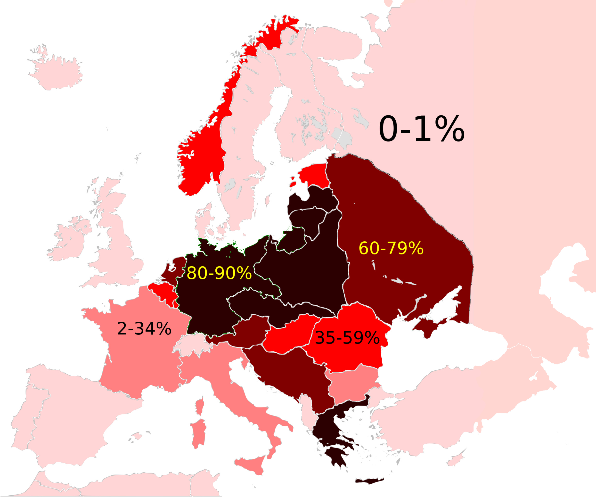
Map of the Jewish Holocaust death toll as a % of the total pre-war Jewish population by country/region
|
| تریخ | (UTC) |
| سروت |
This file was derived from: Weimar Republic 1930.svg:  |
| لکھاری |
|

|
This historical map image could be re-created using vector graphics as an SVG file. This has several advantages; see Commons:Media for cleanup for more information. If an SVG form of this image is available, please upload it and afterwards replace this template with
{{vector version available|new image name}}.
It is recommended to name the SVG file “Holocaustdeathtoll%.svg”—then the template Vector version available (or Vva) does not need the new image name parameter. |
| This is a retouched picture, which means that it has been digitally altered from its original version. Modifications: Changed map. The original can be viewed here: Weimar Republic 1930.svg:
|
لائسنس –
میں، اس کم دے کاپیرائٹ دا مالک، اس کم نوں اس لائسنس دے مطابق چھاپدا واں:
ایس فائل نوں کریٹو کامنز Attribution 2.5 پولینڈ لائسنس دتا گیا.
- تہانوں کھلھ اے:
- حصہ کرنا – کاپی، ونڈنا تے کم بھیجنا
- فیر رلانا – کم نوں فٹ کرنا
- تھلے دتیاں شرطاں نال:
- کس دے ناں – تسیں لازمی ایس کم دے بناں والے بارے دسو جنج اونے آکھیا اے یا جنج لسنس چ آکھیا گیا ہے۔
- اکو جہا شئیر کرو۔ – اگر تسیں بدلدے یا ایس کم تے بناندے تے بنن والے کم نوں اینج دے لسنس نال ای ونڈو گے۔
پہلا اپلوڈ دا ریکارڈ
This image is a derivative work of the following images:
- File:Weimar_Republic_1930.svg licensed with Cc-by-sa-3.0
- 2011-10-27T03:00:17Z Alphathon 450x456 (480732 Bytes) Minor tweak
- 2011-10-27T02:49:21Z Alphathon 450x456 (480434 Bytes) Tweaked Romanian borders
- 2011-10-27T02:30:44Z Alphathon 450x456 (476278 Bytes) A few minor fixes (Malta grouped with UK, North Cyprus removed, a few Greek islands moved to Italy per 1930 ownership).
- 2011-10-27T02:10:50Z Alphathon 450x456 (477608 Bytes) == {{int:filedesc}} == {{Information |Description={{en|A Map of the Weimar Republic within Europe circa 1930.}} |Source=*[[:File:Blank_map_of_Europe.svg|]] |Date=2011-10-27 02:10 (UTC) |Author=*[[:File:Blank_map_of_Europe.svg
Uploaded with derivativeFX
فائل دی تریخ
فائل نو اس ویلے دی حالت وچ ویکھن واسطے تاریخ/ویلے تے کلک کرو۔
| تریخ تے ویلہ | نکی مورت | پاسے | ورتن والا | تیپّݨی کرو | |
|---|---|---|---|---|---|
| موجودہ | ۱۸:۲۳, ۳ ستمبر ۲۰۲۲ | | ۲,۴۵۷ × ۲,۰۴۹ (۱.۲۹ میگابائٹ) | Рагин1987 | Extended map |
| ۰۴:۱۵, ۱۶ اگست ۲۰۱۲ |  | ۲,۰۰۰ × ۲,۰۲۷ (۵۹۳ کلوبائٹ) | Futurist110 | == {{int:filedesc}} == {{Information |Description={{en|Map of the Weimar Republic within Europe circa 1930.}}{{de|Karte der Weimarer Republik/Deutsches Reich innerhalb Europa, ca. 1930}} |Source={{Derived from|Weimar_Republic_1930.svg|display=50}} |Dat... |
فائل دی ورتوں
اس فائل نال جڑیا کوئی صفحہ نئیں۔
فائل ویاپک ورتوں
ایہہ دوجے وکیاں ایس فائل نوں ورتدے نیں –
- ar.wikipedia.org تے ورتوں
- en.wikipedia.org تے ورتوں
- Evidence and documentation for the Holocaust
- Aliyah Bet
- History of the Jews in Europe
- Wikipedia talk:WikiProject Israel/Archive 4
- Wikipedia talk:WikiProject Judaism/Archive 29
- User:OnBeyondZebrax/sandbox/The Holocaust
- Talk:The Holocaust/Archive 31
- Genocides in history (World War I through World War II)
- es.wikipedia.org تے ورتوں
- fr.wikipedia.org تے ورتوں
- gl.wikipedia.org تے ورتوں
- hy.wikipedia.org تے ورتوں
- id.wikipedia.org تے ورتوں
- it.wikipedia.org تے ورتوں
- sc.wikipedia.org تے ورتوں
- simple.wikipedia.org تے ورتوں
- sr.wikipedia.org تے ورتوں
- tr.wikipedia.org تے ورتوں